
Chamba Uttarakhand is a small hill town in Tehri Garhwal, and a 440-metre tunnel runs beneath its main market. The Border Roads Organisation dug it so that Char Dham traffic heading for Gangotri could skip the town’s crowded bazaar. That one detail says a lot about the place. Chamba sits on a crossroads, and most people drive straight through.
This guide is for the ones who’d rather stop. It covers where Chamba is, how far it is from Rishikesh, Dehradun and Delhi, the best places to visit in Chamba Uttarakhand and nearby, and what the weather does in winter. It’s a researched guide built from official tourism pages, government sources and regional travel references, not a first-person trip diary. The sources are listed at the end.
Where is Chamba in Uttarakhand, and how high is it?
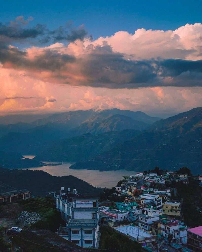
Chamba is a town in the Tehri Garhwal district, on the road that links Rishikesh and Mussoorie with the Tehri Dam reservoir. Its height is about 1,676 metres (roughly 5,500 feet) above sea level, according to Uttarakhand tourism material, and a university in the area gives the same altitude. One older magazine guide says 6,500 feet. That’s close enough to the same thing.
The district headquarters, New Tehri, is only 11 km away, according to the Tehri district website.
Is Chamba in Himachal or Uttarakhand?
Both, which is the problem. There are two unrelated places called Chamba: a town and district in Himachal Pradesh, and this smaller town in Uttarakhand. Anyone searching for flights, hotels or bus tickets should add “Tehri Garhwal” or “Uttarakhand” to the query. Otherwise the results can send them hundreds of kilometres in the wrong direction.
How to reach Chamba Uttarakhand: distance from Rishikesh, Dehradun and Delhi
Chamba is about 60 to 65 km from Rishikesh and roughly 283 km from Delhi by road. The route follows NH58 from Delhi to Rishikesh, then NH94 on to Chamba via Narendranagar, according to an Outlook Traveller guide. The same guide puts the Delhi drive at about nine hours.
Distances from Rishikesh differ by source. Or, to put it better, they differ by a few kilometres depending on where each source measures from:
| Source | Rishikesh to Chamba |
| Outlook Traveller | 59 km |
| Uttarakhand tourism listing (via eRail) | About 60 km |
| Sri Dev Suman Uttarakhand University | About 65 km |
A reasonable planning number is 60 to 65 km. By bus, the university says Rishikesh takes about two hours, while Haridwar and Dehradun take about three.
Other practical details, all from the sources above:
- Nearest airport: Jolly Grant, Dehradun. Outlook Traveller lists it at 77 km (about 3 hours); the university says 80 km. Chamba itself has no airport, so “flights to Chamba” really means a flight to Dehradun and a taxi.
- Nearest railway station: Rishikesh is the closest, at 60 to 65 km. Haridwar, at 84 to 90 km, is better connected to major cities.
- Buses and taxis: Buses and private taxis or jeeps run from Rishikesh, Haridwar and Dehradun.
What is Chamba Uttarakhand famous for?
Apples, mostly, and its position. Tourism material describes Chamba as an orchard area and a major apple-growing centre, set against a backdrop of snow peaks and the Bhagirathi valley. After old Tehri went under the reservoir, displaced residents resettled in New Tehri and Chamba, and Chamba grew into a central stop for the district.
Mind you, the town itself isn’t the main attraction. Outlook Traveller’s own take is that people don’t come to Chamba to stay in town. They come for the hills around it.
Places to visit in Chamba Uttarakhand and nearby
Chamba market and the tunnel
The bazaar is the town’s working heart. The tunnel beneath it is on the Rishikesh-Dharasu highway (NH94), and the BRO reported its north and south portals meeting in May 2020. Reported length is 440 m, though a few outlets round it to 450 m. Officials said the tunnel shortens the route by about a kilometre and clears through-traffic out of the market.
(A small digression: the tunnel exists partly because the alternative was demolishing shops and buildings along the main road. That’s why the market still stands in its original spot.)
Viewpoints over the Himalayas and Tehri Lake
Chamba sits high enough to catch distant snow peaks on clear days, and several travel listings describe views toward the Bhagirathi valley and Tehri Lake from the hillsides around town. Exact viewpoint names and entry details vary by source, so ask at a local stay before heading out.
Apple orchards
The orchards are part of the town’s identity, according to tourism pages. For visitors, the practical question is timing. Local orchardists would know when blossom and harvest fall, and that’s worth asking about before booking.
Surkanda Devi Temple
This hilltop shrine is the best-known site near Chamba. It’s dedicated to Goddess Parvati and associated with the Shakti Peeth tradition, and a Ganga Dussehra fair is held there in autumn. The altitude is listed at about 3,030 m by two sources and 2,903 m by Uttarakhand tourism, so call it roughly 3,000 m.
Distance depends on who’s measuring:
| Source | Chamba to Surkanda Devi |
| Shubh Panchang | 10 km |
| eUttaranchal | 24 km |
The shrine is reached by a short uphill walk from Kaddukhal village, roughly 2 to 2.5 km depending on the source. Verify the distance on a map before setting out.
Kanatal
Wikipedia and travel sites put Kanatal about 18 km from Chamba on the Chamba-Mussoorie road. It’s known for camping, forest walks and its apple orchards. Several Kanatal guides list Tehri Lake and Dhanaulti as easy add-ons.
Dhanaulti, New Tehri and Tehri Dam
Dhanaulti sits further along the Chamba-Mussoorie road and has an eco park, deodar forest and, in winter, snow. New Tehri is the closer neighbour at 11 km, a planned township overlooking the reservoir. The Tehri Dam, one of the area’s big attractions, is farther out; a nearby university lists it at about 20 km from its campus.
Things to do in Chamba Uttarakhand
- Short hikes and temple walks. The Surkanda Devi climb is the standard one.
- Camping. Camps cluster around Kanatal, such as the Kodia forest area, rather than in Chamba proper.
- Market wandering and food stops. Quick, cheap and reasonably central.
- Road-tripping. The Chamba-Mussoorie and Chamba-Tehri stretches are the draw for many visitors.
A one-day plan
This is a suggested sequence based on the distances above, not a tested route:
- Start early from Rishikesh or Dehradun and reach Chamba by mid-morning.
- Walk the market and have a tea stop.
- Drive toward Kaddukhal for the Surkanda Devi climb.
- Continue to Dhanaulti or Kanatal for sunset and dinner.
- Return the same evening, or stay overnight to avoid driving hill roads in the dark.
Keep the timings loose. Hill roads add time.
Chamba Uttarakhand weather, snowfall and the best time to visit
Chamba has cold winters with occasional snowfall, according to one travel listing. Heavier snow is better documented higher up: nearby Surkanda Devi and Kanatal get snow mainly between December and February, and Kanatal’s snow season peaks in January and February.
So don’t count on snow in town itself. Chamba is at about 1,676 m, and the reliable snow is on the ridges above it.
For general sightseeing, guides for neighbouring Dhanaulti rate March to June as the best months, with December and January the pick for snow.
For temperatures and live forecasts, check the India Meteorological Department before leaving. Weather in the hills shifts fast, and landslides on the highway during the monsoon can close roads with little notice.
Where to stay
Options in and around Chamba include hotels, resorts and homestays, with more camps and resorts in nearby Kanatal and Dhanaulti. A separate guide on stays in Chamba is planned for this site. [Add internal link to hotels blog.]
Frequently asked questions
What is the PIN code of Chamba, Uttarakhand?
Addresses for the Chamba-Mussoorie road and the Surkanda Devi area use 249145. Confirm with India Post for a specific address.
Is there an airport or railway station in Chamba?
No to both. The nearest airport is Jolly Grant in Dehradun, and the nearest railway station is Rishikesh.
How far is Chamba from Delhi?
About 283 km by road, roughly nine hours, according to Outlook Traveller.
Is Chamba good for a weekend trip?
Yes, for road trips and short breaks. It works best as a base for nearby places such as Surkanda Devi, Kanatal and Dhanaulti.
Does it snow in Chamba?
Occasionally, according to travel listings. Heavier snow falls on higher ground nearby from December to February.
How this guide was researched
This guide draws on official Uttarakhand tourism and Tehri district government pages, a university in the area, reports on the Chamba tunnel from Indian news outlets and the Border Roads Organisation, and established travel references. Where sources gave different figures, both are shown. The guide was last updated in November 2026. Road conditions, hotel details and distances change, so verify them before travelling.
Sources:
- Uttarakhand Tourism listing for Chamba (eRail)
- Tehri Garhwal district website, New Tehri
- Sri Dev Suman Uttarakhand University, location and access
- Outlook Traveller, Chamba quick guide
- Daily Pioneer, BRO tunnel milestone
- eUttaranchal, Surkanda Devi Temple
- Stay Vista, places to visit in Kanatal (distance and snowfall)
- Maps of India, Dhanaulti tourism (best time)

Travel Writer | Founder of Welcome Uttarakhand
Amit Negi has been exploring Uttarakhand’s temples, trekking routes, hill stations, and hidden villages for several years. Through Welcome Uttarakhand, he shares practical travel guides, local insights, and itinerary tips to help visitors plan memorable trips across the state.